Environmental Mitigation
When undertaking projects, MDTA’s first course of action is to avoid and minimize impacts to sensitive natural resources such as forests, wetlands and streams as much as possible while still achieving the transportation goals and objectives of its projects. MDTA performs mitigation for unavoidable impacts within the project limits or on MDTA right of way wherever possible; however, in some cases off-site mitigation must be performed. The environmental mitigation is within the watersheds of the I-95 NB ETL Program.
Stream and Wetland Restoration
- Over 13,000 linear feet of stream creation, restoration, and preservation currently
- over 650 linear feet of additional stream restoration will occur during the summer of 2023
- Over 22 acres of wetland creation, enhancement, and preservation
Forest Plantings and Protection
- Nearly 20 acres of forest planted within the I-95 ETL project limits
- Over 25 acres of reforestation in Baltimore County at MDTA owner property on Raphel Road
- Nearly 20 acres of existing forest on 3 MDTA properties will be protected with a restrictive covenant
- Future Plantings of approximately 7 acres:
- Days Cove DNR owned site in Baltimore
- Willoughby Beach parcel owned by Izaak Walton league in Harford County
Environmental Mitigation Projects include:
- Carsins Run
- I-895 in Lansdowne
- Eccleston
- WUS 18A
- Raphel Road
The MDTA performed stream restoration in Aberdeen, Maryland, within the Swan Creek watershed, along Carsins Run and its tributary. Carsins Run is a stream located within MDTA right-of-way just north of the I-95/MD 22 interchange and west of I-95, within the Section 200 limits but outside of the current construction limits of the I-95 NB ETL Program. At the time that I-95 was originally built, Carsins Run was channelized and given a concrete substrate. Subsequently, the bottom of the concrete channel washed out, and portions of the concrete bank failed. In addition, an intermittent unnamed tributary to Carsins Run, referred to as Ripken Tributary, was actively eroding both vertically and laterally, likely due to altered hydrology resulting from the nearby Ripken Stadium development.
- MDTA restored over 1,000 linear feet of Carsins Run and its Ripken Tributary and created over 0.11 acre of wetlands
The objectives of the stream restoration included stream stabilization, sediment and nutrient reduction, floodplain reconnection, and aquatic habitat improvement. The stream restoration activities within Carsins Run included removing the existing concrete substrate, adding weir structures and riffle grade controls, planting live stakes along the banks, and replacing a failed storm drain. Within the Ripken Tributary, MDTA realigned the stream, reconnected it to its floodplain, created riffles and deep pools, and enhanced riparian vegetation.

The MDTA performed stream restoration in Baltimore County, Maryland, within the Patapsco River watershed, along an unnamed tributary to the Patapsco River. The key objectives of the stream restoration were to stabilize upstream conditions within MDTA right-of-way as well as provide a self-sustaining stream and riparian system that is resilient, reestablishes a natural valley bottom ecosystem, and promotes improved biological and ecological functions. Prior to restoration, the unnamed tributary exhibited little bedform diversity, had deeply incised banks, lacked any significant sinuosity, and lacked floodplain connection due to over-widening of the channel. Flow in the upper reach of the tributary appeared to be subterranean through several sections due to sediment aggradation within the channel.
During 2020-2021, MDTA restored over 2,000 linear feet of the unnamed tributary. Primary objectives included sediment and nutrient reduction, floodplain reconnection, and aquatic habitat improvement. The stream restoration activities conducted at this site included increasing channel sinuosity, adding riffle and other grade control structures, and planting on-site native herbaceous and woody vegetation. Given the restoration’s focus on hydrological, hydraulic, and geomorphology improvements, significant functional uplift of the stream and its associated floodplain was provided in conjunction with high density native tree and shrub plantings and invasive species removal. Aquatic habitat improvements resulting from the restoration include increased benthic habitat, enhanced floodplain connection and wetland creation, floodplain microtopography creation, and improved and expanded native riparian buffer habitat.
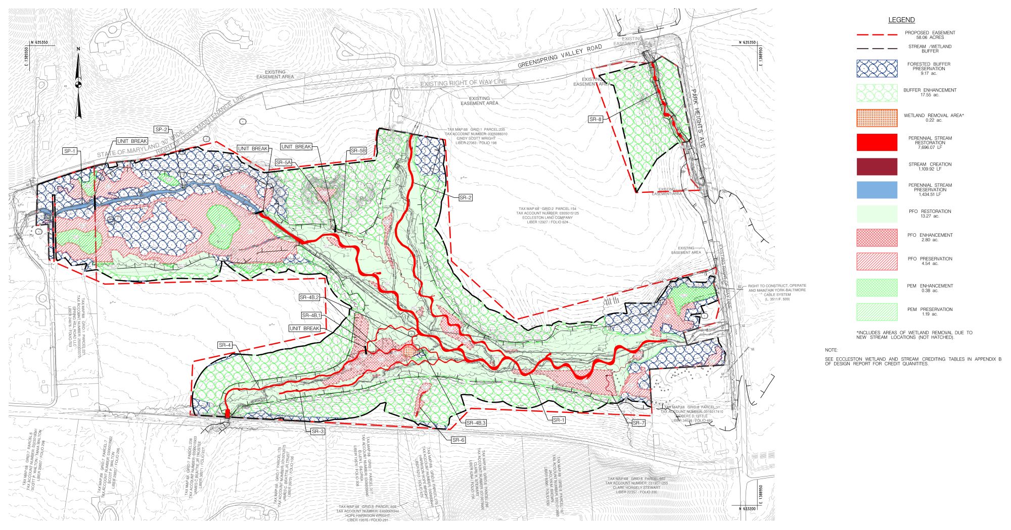
The Eccleston mitigation site is located within the Jones Falls watershed in Owings Mills, Maryland. The Jones Falls and its tributaries have been straightened/channelized, impounded by damming, and diverted through piping. The stream buffer was largely deforested, and much of the historical wetland that was present on the site was impacted by historic agricultural activities. These historic activities led to water quality and habitat impairments resulting from sediment and nutrient pollution, diversion of baseflow, loss of canopy and stream cover, and disconnection from historic base-level floodplain, wetlands, and groundwater.
The stream restoration design utilized is a modified Rosgen/floodplain restoration approach. The streambed profile was located within the native valley basal gravels identified throughout the valley bottom, and furnished substrates of geologically appropriate composition and size in areas lacking native material or where needed for transitional reaches. A hydrologic and hydraulic regime was created where the stream is fully connected to restored floodplain wetlands and floods frequently in a non-erosive manner in order to maintain geomorphic and biological functions. A low-energy floodplain/wetland environment was developed, along with a diversity of woody habitat and debris structures both in the channel and in the floodplain for habitat. In addition, extensive reforestation and wetland restoration will result in establishment of vegetated stream buffers an average of 150 feet wide.
This method of restoration restored historic floodplain wetlands and enhanced the existing isolated wetlands by incorporating them into a large wetland complex that will be well-connected to the Jones Falls, its tributaries, and groundwater. Further wetland enhancement will be accomplished through removal of invasive species. Existing high quality forested and emergent wetlands located in the less historically impacted portions of the Eccleston site will be preserved through a perpetual easement; these wetlands have mature trees, varied hydrology, and contain sensitive species such as wood frogs. They also provide riparian buffers for existing high-quality stream reaches that contain trout throughout the year.
Over 10,000 linear feet of stream creation, restoration and preservation was performed at the Eccleston site. In addition, approximately 22 acres of wetlands were restored, enhanced and preserved. The mitigation activities at Eccleston have enhanced existing low-to-moderate quality wetlands and streams to become high quality; restored/recreated historic high-quality wetlands; and preserved existing high-quality wetlands. By comparison, the resources impacted by the I-95 ETL highway work are primarily of low or moderate quality. The wetland and stream mitigation at Eccleston provides substantial functional uplift compared to the impacted resources.

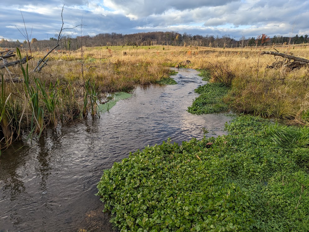
Eccleston Mitigation Site After Remediation Work

WUS 18A is a Use III tributary to the Little Gunpowder Falls and is located within the Little Gunpowder Falls watershed (02-13-08-04). It is a perennial stream located northwest of I-95 near mile marker 73.0 within MDTA right-of-way and within the limits of the I-95 ETL project area. WUS 18A is located within an urbanized watershed where a significant amount of the waterways upstream of the project site have been piped. These impacts result in flashy and intense discharges through the open stream channel within the project site. In addition, the urbanized areas can negatively impact the water quality and habitat of the project stream reach.
Over 650 linear feet of stream restoration will occur at WUS 18A. The proposed restoration technique to be utilized is floodplain restoration, which focuses on re-exposing a native hydric soil layer as the surface of a restored floodplain and using basal gravels native in the site to be the base level of the stream channel. The basis for the design is to develop a stable channel dimension, pattern, and profile that will transport the fine sediment load from the upper watershed over time while maintaining a stable channel dynamic equilibrium, where channel dimension and facet sequence vary only within the stable natural variability of the site.
MDTA has planted over 5,000 trees on approximately 25.4 acres in Baltimore County at the Raphel Road MDTA owned site, which is adjacent to the project limits. The species composition of plants chosen is similar to what would be found in local forest communities. To encourage establishment of a more natural community, species were planted in drifts rather than a grid pattern. Deer protection was included on over 3,500 trees. In addition, chain link fencing was added to portions of the perimeter of the site to prevent resident beavers from gnawing on the trunks of the recently planted trees.


